The information presented is there to be used and enjoyed but please be sure to
acknowledge the source and author if you use any material.
![]()
My Memories of Thorne
by Peter Hackney
"See all of Peter's 'photos' here on Flickr"
Thorne 1975
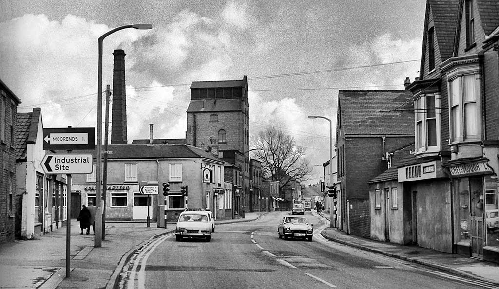
I didn't take that many photos of Thorne in the 1970s but it did seem to have a lot of the traffic lights. They were "the" traffic lights in those days as there were no others in town! This is looking from Fieldside down King Street with a K-reg MGBGT heading towards us and an Austin 1800 and a Mini (see its reflection in Cheeseborough's window) going the other way.
The industrial estate signposted down Field Road & King Edward Road was presumably Coleman Road although much smaller then than today.
On the right Cheeseborough's is still open with its wooden guard in the entrance indicating that this shot was taken on a Sunday - hence the few cars around. Next to Cheeseborough's Dowse's the bakers is closed and boarded up, the bakery itself on Queen Street behind also closed by now.
Darley's Brewery is still in full operation though, chimney smoking, and the North-Eastern pub on the corner, like most others, serves Darley's Ales. I don't know what it serves now but the brewery is long gone (although the building is still standing) and the pub has reverted to its old name of the Corner Pin.
The building with its awnings out over the pavement in the distance was a newsagents where I worked as a newspaper boy at one time in the 1960s.
On the extreme left the old brick building still stands today and is equally as derelict-looking even though it is lived in. Shuker's pork butcher's used to be in the building alongside and on the corner by the traffic lights was Raper & Barley groceries.
Darley's Brewery has closed but the tower still dominates; the North Eastern pub had become the Corner Pin.
Thorne traffic lights Easter 1975
Thorne is in South Yorkshire or the West Riding of Yorkshire if you never accepted the 1974 changes. It was a market town for the surrounding villages, has been a settlement since Saxon times, approx. AD 700 & it is mentioned in the 11th century Domesday Book. The town grew up on a gravel ridge which being 5m above sea level in a region of wetlands on or below sea level remained dry throughout the year, similar to the Fens or Holland in many ways. In the same way that Holland & the Fens were drained over many years - part of Lincolnshire is known as New Holland - Thorne Moors were drained by Dutch engineers in the early 17th century. Thorne became the market town for the rich agricultural lands in the area. With the opening of Thorne Colliery & the building of miner's housing in Moorends it became a pit town but retained its market town status. Since absorbtion into Doncaster Metropolitan Council in the 1970s it has lost its independence & is the worse for it being a distant (10 miles away) outpost, out of sight & out of mind. Although it has the highest council tax of the district it doesn't seem to have much to show for it.
This exciting view is looking down King Street from the traffic lights - the only ones at that time - at the junction with Field Road. Darleys brewery tower is prominant on the left & the North Eastern is a Darley's pub. The sign shows the trademark of Darley's Ales, a mailed horse.
Darley's was taken over by Vaux in the 1980s & a promise was given to keep the brewery open for at least 5 years. Of course dead on 5 years later they announced its closure. Fortunately for Thorne the tower & King Street frontage was retained - Co-op supermarket was built behind - so this view is almost unchanged today.

Thorne church Peel Hill - 24th December 2006
Peel Hill Castle. Like the fireplace in my house in Leicester, Thorne church in South Yorkshire is built from Permian dolomite (Yorkshire stone) but unlike my fireplace it was manhandled over 10 miles from west of Doncaster in the Norman period. Its foundations date from the 12th century.
Built on a gravel hill standing 5m above the wetlands, this area is the heart of the old town & the hill in front of the church is known as Peel Hill & in fact is the remains of the motte of a Norman motte & bailey castle also built in the 12th century. There are no indications of a stone fortification on the hill & it would probably have had only a wooden palisade around the top where the Normans could have retreated to when the Thornensions got stroppy.
The Thornensions these days show their respect for history by riding their mountain bikes up & down the hill wearing away the grooves which can be seen.

Thorne Fieldside School 24th December 2006
The slowly deteriorating roof of the one-time Fieldside Junior School on Fieldside, Thorne, South Yorkshire. For many years after closure as a school it was used as a further education centre but today further education for enjoyment is not allowed & all courses must lead to an exam & qualification. Because of this many people (particularly the old who have no need for the qualification) have dropped out. The building is now dropping out too.
A few years ago my mother contacted Doncaster Council to enquire whether the building was Listed. After checking in the system she was told it wasn't but the 18th century stone milepost in front of it was! Unfortunately within weeks the Listed milestone disappeared. It has taken another 10 years but Fieldside School is disappearing too.

Thorne South - 15th May 1974
The open wasteland that the Great Central Railway at Thorne South in South Yorkshire became after rationalisation. The station, opened in 1864, is on the old Manchester, Sheffield & Lincolnshire Railway, later Great Central Railway, line from Sheffield to Grimsby.
The permanent way hut on the right sits in isolation & what once was an island platform with goods lines to the right is now an unusally wide bare expanse against which the Scunthorpe bound dmu is waiting. Access to the platforms used to be via a dark subway with steps up.
Today this has been swept away & new basic platforms closer to the South Common estate have been built behind the camera. To the left is the old stationmaster's house now in private hands & being extended

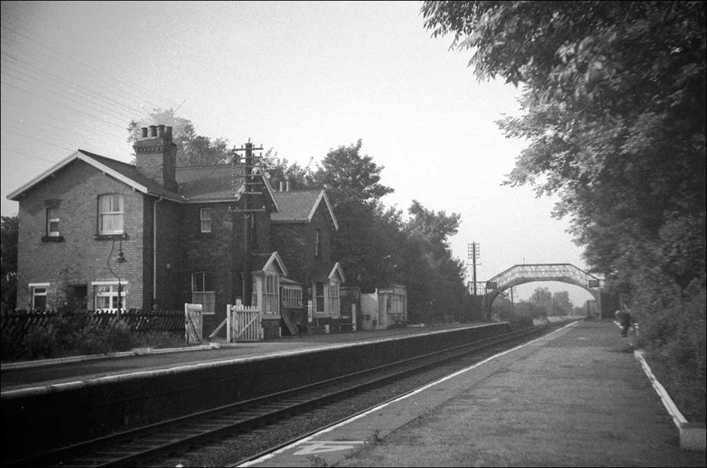
Thorne South Station August 1968
Thorne South Station, South Yorkshire, August 1968. The station is on the old Manchester, Sheffield & Lincolnshire Railway, later Great Central Railway, line from Sheffield to Grimsby. The awnings once extended the full length of the platforms but by this time had been cut back. The goods loop & cattle dock to the left had also been lifted.
My father was a porter on the LNER here before and after WWII before leaving to join the NCB in 1947 where wages, if not working conditions, were much better. The station has since been rebuilt on a site close to where the signal box stood.

Thorne North Station - 23rd May 1977
A Hull bound - next stop Goole - 2 car dmu enters Thorne North, North Eastern Railway, station from the Doncaster direction beneath NER footbridge number 31. The train is passing from former Great Central rails onto the North Eastern at this point.
At the time I never thought that a picture of a first generation dmu would really be of interest but since their demise they have become just that. In fact the green liveried dmu operating at the Great Central Railway at Loughborough is always busy. Last Sunday running as "Daisy" during the Thomas Weekend it was as packed as the Thomas -hauled trains themselves.
Thorne North station - July 1968
Thorne must be one of the few small towns to come through the Beeching Years relatively unscathed. In addition to South station on the Great Central line it still boasts a second station; Thorne North on the North Eastern Railway line to Goole & Hull.
As a teenager I do remember reading the newspaper headlines when the Beeching Report came out in 1963 but it hardly made an impact on me because Thorne's stations were unaffected.
My Great-Grandfather moved from Spalding in Lincolnshire to Thorne in 1869 to work for the NER. He spent most of his working life as a Porter at Thorne North.
I'm pleased to say that, unlike Thorne South, most of the station buildings still stand today, including that fine NER footbridge.
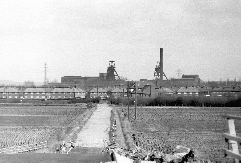
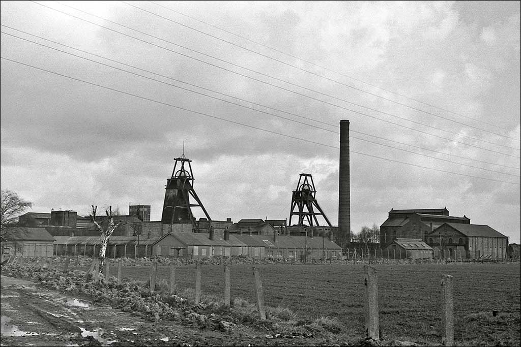
Thorne Colliery Moorends - Easter 1975
A view eastwards of Thorne pit in Moorends from the M18 motorway bridge which was still under construction at Easter 1975. The fields in the foreground belie the industrial scene showing that, like many collieries, Thorne pit was built in an essentially rural setting.
It was the deepest & furthest east mine in the South Yorkshire coalfield opening in 1926. This changed the small market town of Thorne into an industrial centre although the pit village of Moorends was built a discreet distance from the old town. It was a very modern development and the owners, Pease & Partners, provided model housing for its workers who had to be encouraged to move into this new green-field site from all over the country. My maternal grandfather & grandmother moved here from Thurnscoe near Barnsley. All the houses had good sized rooms, separate bathrooms and spacious gardens.
All trace of the original colliery seen here is now erased & even the later 1980s winding gear has been dismantled. Even the pit tip was removed in 1974-5 to be used for the motorway. With the closure of virtually all the South Yorkshire pits in the 80s & 90s unemployment in Moorends has been running at very high levels. I'm still not sure where people work today but you can be sure it's not a short walk to get there as it used to be. The M18 is jammed with commuters.
The North Eastern Railway's Thorne Junction to Goole & Hull railway line passes right to left in front of the houses. The unmanned level crossing, centre, was closed to road traffic together with 2 other unmanned crossings further south in the late 1960s after numerous accidents. Car & van drivers would ignore the Stop, Look & Listen signs & come off the worst in collisions with speeding trains.
The large building to the right of the lane in front of the houses is the Winning Post public house. Indeed the road was known as the "Winning Post" lane. My grandmother's house in The Avenue, where I was born, is out of shot to the left.

(Picture on right) The view from from Grange Road Moorends of the colliery complex. It shows the pit complex as built in the 1920s before demolition of various parts & well before the headgear was completely replaced by modern structures over the two shafts. It had been closed "temporarily" in 1956 but despite millions of pounds spent on repairs and replacements it never reopened. The pumps were turned off in 2004 and the shafts filled by 2006.
The entrance road in the foreground has already been bulldozed to be replaced by a new road which turned off the Goole road to the west of the railway and crossed it by a new & expensive bridge before entering the site from the west. In this way heavy coal traffic would no longer pass through the centre of Moorends & along Grange Road. Today no coal traffic passes at all because the pit has been razed to the ground. However plenty of heavy traffic still passes through the centre of Moorends.
The low buildings in the foreground were the accounts & payment department. In the early 1950s when I was a child I used to ride on the crossbar of my father's bike when he went to pick up his wage packet from here. The place was a hive of activity in those days

(Picture left) Colliery headgear Easter 1975. Disused since 1956. The sun does sometimes shine in South Yorkshire & my orange filter made the most of the contrasting sky. picture right The winding gear & chimmney are contrasted against the dramatic sky by the orange filter. Lots of siver birch weeds in the yard now as the pit had been under repair/in mothballs for almost 20 years.
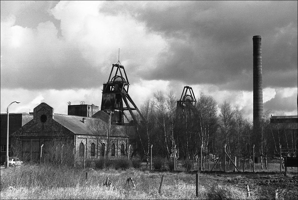
Thorne Colliery South Yorkshire Easter 1975
My 1961 Mini 7888VT is sitting outside the doors of the old engine shed at Thorne Colliery. The winding gear & chimmney are contrasted against the dramatic sky by the orange filter. Lots of siver birch weeds in the yard now as the pit had been under repair/in mothballs for almost 20 years.
Today all this - and its 1980s replacement - has been swept away. The mine never reopened.

Thorne Canal - 24th October 1976
View east from Thorne Lock to Dunstans shipyard with a barge being fitted out, 24th Oct 1976. Richard Dunstans built ships here for over 100 years, launching them sideways into the canal & even made quite big ships including ocean going tugs. I had a school project in 1959/60 following the building, launching & delivery of a tug to Kuwait for service in the Persian Gulf.
The larger ships would be launched here but towed down past the railway bridge at Thorne South in order to fit the higher superstructure & masts before sailing down the Sheffield & Keadby canal to Gunness Wharf near Scunthorpe where they could access the navigable River Trent & hence the Humber & North Sea. During WWII many lighters were built here for war service.
Needless to say no ships are built in Thorne now and the whole area is covered with overpriced modern housing. You don't see so many Coles cranes about these days either. The modern building in the centre of the view is the training tower of the new Fire Station - the only "high-rise" in town

Thorne M18 under construction Easter 1975
The Thorne to Goole section of the M18 motorway in South Yorkshire under construction near Thorne, looking north. The pit tip at Thorne Colliery was removed and re-used as building material to construct the embankments for this stretch, thus eliminating one of the features of Thorne's skyline. All other trace of the mining history of Thorne & Moorends has now gone with the removal of the pit head gear last year.
Prior to this motorway opening all through traffic passed by Thorne town centre with its canal bridge, narrow roads & traffic lights - stationary hell at holiday times when the whole of the West Riding headed for the Yorkshire coast.
After the M18 opened traffic levels in the town dropped dramatically but today it seems at times to be no different than it was 32 years ago.

Thorne 1970s
The view looking northwards from the top of Thorne St Nicholas church tower in the 1970s.
In the foreground is Thorne Grammar School, the majority of which is now demolished & what was left - the 1930s frontage facing the camera - converted into flats. I attended this school from 1960-67 but a new Academy was recently built to replace it at the bottom of the former playing fields off to the right.
On the centre skyline is the outline of the headgear & chimney of Thorne Colliery located in Moorends. The pit opened in 1928 & closed "temporarily" for repairs in 1956 due to the continuing water problems in the shafts. The original infrastructure built in 1925 can be seen here but it was demolished & upgraded in the 1980s. However, despite this investment the pit never reopened & this distinctive Thorne landmark has now gone - even the new headgear. It still feels strange not to be able to see it looking down Alexander Road from the crossroads.
The flat nature of the countryside is obvious in this scene but the church is built on a gravel ridge. This used to remain high & dry whenever the surrounding area was flooded which was most of the time as the Rivers Don, Aire, Idle & Ouse meandered across the plain. Hence the reason Thorne became a settlement. The ribbon of white just discernable in the right distance is the River Ouse close to where it joins the Trent to form the Humber.
All the rivers have been canalised & the land drained & warped with most of it put to highly productive agricultural use. The non-agricultural land is mainly peat bog & the area beyond the mine was known as "Thorne Waste or Moors". However industrial peat extraction has ravaged these remaining wetlands over the last 30 years.
Thorne used to have its own District Council but is now part of the Doncaster Metropolitan Borough. Being on the extreme eastern edge of the Borough people feel a bit left out.

This is the view to the west & looks down Church Street to the Market Place with the Finefare supermarket on the corner. The white building in the right centre is the Little Pork Pie Shop on The Green.
Further away & to the right is the firestation tower & gasometer. Beyond & to the right the large warehouse is part of Richard Dunstan's shipyard on the Stainforth & Keadby canal bank. Both Dunstan's & the Gasometer are gone today - as is Finefare for that matter.
On the left horizon is Hatfield colliery & its pit tip with Thorpe Marsh power station to the right of it. At this time Thorpe Marsh was still operational but today it has closed although the cooling towers still stand.
Hatfield colliery has closed & reopened several times since privatisation but now Chinese investors are planning to mine the coal for a gas-from-coal power station on site.
Until the late 17th century the countryside in the distance was part of a royal hunting ground known as Hatfield Chace. It was an extensive wetland environment created by flooding of the Rivers Don, Aire & Idle. Dutch engineers drained the Chace.

Swinging further east from the previous photo this view is looking southwestwards from Thorne St Nicholas church tower. Thorne Park is in the trees in the left background.
The main road running southwards in the centre is South Parade - the A614 which at that time was the main road from Bawtry on the A1 to Goole, Hull & the Yorkshire coast. In summer a tremendous amount of holiday traffic used this road to get from Sheffield/Rotherham to Bridlington & Scarborough so the town would be jammed solid. Now the M18 has been built this traffic bypasses Thorne but the volume of local traffic has built up so much over the last 30 years that sometimes Thorne is just as jammed!
At the far end of South Parade the new canal bridge can just be made out next to the Canal Tavern. The old bridge was a swing bridge & with much more canal traffic - commercial in those days - the traffic jams were made even worse as it was opened & closed on a regular basis.
The open countryside is more of what was Hatfield Chace and now is rich agricultural land.

Moorends Easter 1975
Moorends level crossing & signal box is about a mile north of Thorne North station on the North Eastern Railway line to Goole & Hull. At one time there was a short siding on the Down side just beyond the gates and the nearest signal had a distant arm (for Thorne Colliery box). This telephoto shot was taken from the unmanned crossing behind the Winning Post. The horizontal white board on the right is the whistle board for this crossing.
Today nothing remains but the two tracks and lifting barriers on the road. No sign of the once never-ending coal trains either. However I have just (Jan 2010) discovered that the gate-gear from this box was preserved and is still in use in New Bridge box on the NYMR. Excellent.
Interesting to see a church steeple on the horizon on the extreme right. The land around here is so flat that although Goole is 10 miles away St John's church very clearly stands out.
I was born just off shot on the right in my grandparents house in The Avenue. In theory living so close to a busy railway line so young should have meant that I was hooked on steam trains from an early age. In fact, except for a short foray into trainspotting with the acquisition of an Ian Allan 1957-ish Eastern Region book I really had no interest.
The interest was only stimulated in early 1968 when I read that all the remaining BR steam locomotives would be scrapped by August of that year. A bit late in the game to become a railway enthusiast but just in time to catch the end of LMR steam in Lancashire, at least.

Thorne Market Place - September 1974
A very quiet Thorne town centre - Sunday morning probably. The White Hart is on the left with its building date of 1737 in numbers on the front. It was still a Darley's pub in those days the beer brewed in Thorne. Darleys was bought by Vaux and the brewery closed.
The Halifax Building Society in its pre-bank days occupies the corner of Church Street where Timothy White's and Taylors chemist used to be and the Finefare supermarket is on the right.
Thorne's Norman church dominates the scene on the hilltop, not that it's much of a hill but it was enough to keep Thorne high & dry of the surrounding marshland so that a community developed in Saxon England.
Typical of the 1970s is the sight of the boy on his Raleigh Chopper bike in front of the shops.
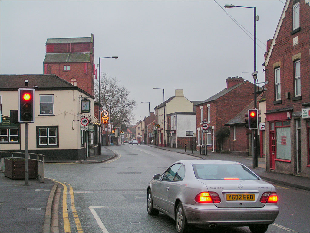
The White Hart, the Market Place and King Street in the sun for a change. - 30th March 2010

Thorne Market Place Xmas 1974
Thorne Market Place before it became an Olde Worlde cobbled piazza bordered by derelict buildings! The market is in full swing just before Christmas.
Pidd's Pork Butchers shop had been there for years and Cooplands for a few years in the old building where Reid's used to be but the Midland Bank building was new and out of keeping really. On the left is what was the the Yorkshire Penny Bank when I was a kid. I just checked and of course it doesn't exist anymore being taken over by the National Australia Bank in 1990 & merged with the Clydesdale.
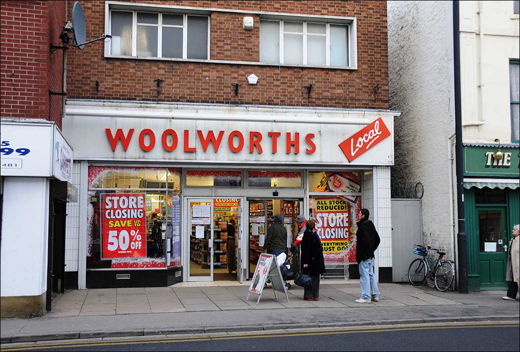
Thorne Woolworths - 18th December 2008
So Woolworths are going bust then. This is the Thorne branch on King Street where many years ago I used to buy my Airfix kits.
When it closes Thorne will have one more derelict building. The shop on the right used to be the Maypole when I was a kid. Whatever happened to the Maypole?
Thorne Grammar School - Summer 1963
This was summer 1963 so it must be 3 Upper Arts in all their 14-year old glory with Miss Binns front & centre. Where are they now?
Sadly I do know that Andy Caines (back row 4th from left) and Steve Harrison (back row, second from right) are both dead, and both tragically young, Andy in car accident back in the 1960s and Steve in the 1980s.

Thorne Grammar School 1966
Vive Audacter! The badge used to say. Did I live boldly I wonder? I like to think so although I felt & feel no great affection for TGS. And anyway I failed "O" Level Latin.
This is VI Lower Science, I think, but I'm wondering what happened to the girls? And what are the button-holes that half the kids are wearing (not me)? Can't be Remembrance poppies as it's the wrong time of year. Anybody recognise themselves?
The school no longer exists, well part of it does but in the throes of being converted into flats - sorry luxury apartments. This photo was taken in one of the two quadrangles. I think the brick wall to the right is the main frontage building which still stands, the rest has gone. A new school named Trinity Academy run by the Emmanuel Schools Foundation (ex-Vardy Foundation) opened in September 2005.

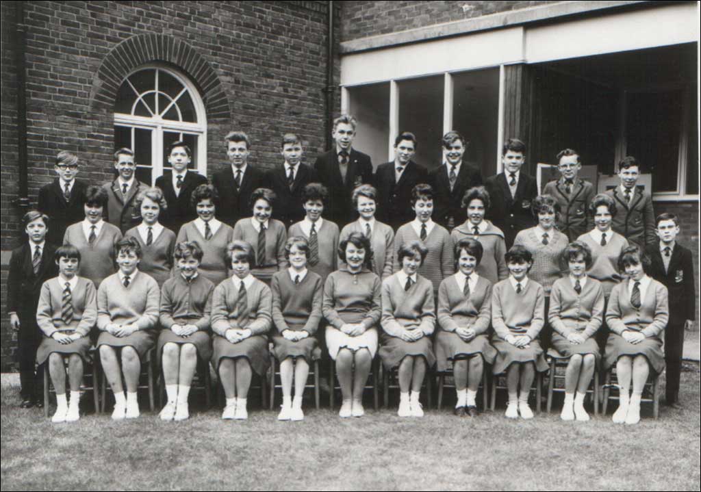
Thorne Grammar School Yorkshire 1968
The second image in the school section of the book "Changing Times, The 1960s" shows a typical 1960s 6th Form group. Of all the possible schools in the UK this one just happens to be the Upper Sixth at Thorne Grammar School in 1968. What happened to the girls I wonder.
I had left the school a year earlier but the connection is my cousin, Mick, on the second row, third from the right. The rest of the faces all look familiar but can't remember any names.
Any of you out there in Flickrland?

The former windmill on Northeastern Road - 10th April 2008
Seen from the entrance to what was the Senior Boys - the Secondary Modern School - on the other side of the road.
The mill is abandoned along with the remains of Oates' shop off to the right. My father started working here as a 14 year old in 1935/6. At that time it was still an operating flour mill although without sails and powered by a diesel engine. All the internal fittings were made of wood and just as they had been when powered by wind.
During WWII the roof of the mill was used as an ARP post.
© Thorne Moorends Regeneration Partnership. All Rights Reserved.